Showing posts with label Topography. Show all posts

Tuesday, 14 February 2012

Amfibia dan reptilia


Amfibia dan reptilia ialah elemen yang penting dalam memastikan ekosistem hutan berada dalam keadaan yang seimbang dan optimum. Secara keseluruhannya, terdapat lebih kurang 299 spesis katak(Norhayati. A) dan 165 spesis ular(Perhiltan) di Malaysia. Spesis-spesis ini menunjukkan morfologi yang unik, tindakbalas yang sensitif terhadap alam sekitar dan adaptasi yang mengkagumkan. 
Akan tetapi, tidak banyak yang diketahui tentang Order haiwan ini oleh masyarakat umum. Kebanyakan dari mereka menggambarkan makhluk ini sebagai ‘terlalu’ bahaya, kotor dan hodoh. Selalunya haiwan ini akan dibunuh(terutama sekali ular) apabila dijumpai tanpa mengira jenisnya. Ini disebabkan kurangnya usaha untuk memperkenalkan organisma tersebut kepada masyarakat. 
Reptilia dari Oder Squamata iaitu ular adalah penting dalam kawalan makhluk perosak seperti tikus. Begitu juga dengan Keluarga Anura iatitu katak. Katak juga menjadi penunjuk biodiversiti yang amat baik dalam menentukan kualaiti air dan alam sekitar di satu-satu kawasan. Ini adalah kerana katak mempunyai kulit paling sensitif dalam kingdom haiwan. Katak menggunakan kulit untuk bernafas dan akan bertindakbalas jika berlaku perubahan kualiti air yang sedikit. Ini dapat dilihat pada Gua Batu Maloi, Johol, Negeri Sembilan. Populasi katak semakin besar semakin dalam gua diterokai. 
Kelangsungan hidup haiwan ini harus diperlihara oleh kita bagi memastikan haiwan ini terus wujud dan menjalankan fungsinya.

Oleh yang demikian, haiwan-haiwan ini haruslah dikesan dan diambil maklumat tentang kedudukannya(GPS), morfologi(kulit, sisik, mata, warna), habitat, bentuk muka bumi dan sebagainya. Maklumat-maklumat ini akan menunjukkan sifat, perangai dan keadaan haiwan tersebut. Ini adalah penting untuk meramalkan bilangan populasi dan keadaan sesuatu habitat tersebut. Haiwan diatangkap dan diambil gambar sebelum dilepaskan. Aplikasi dari kaedah ini adalah luas. Salah satunya ialah pemetaan spesis dari pelbagai genera. Pemetaan ini akan memberi gambaran yang umum kepada penyelidik akan datang. Jesteru itu, usaha seperti konservasi dapat dijalankan dengan lebih mudah.
Bagi menyampaikan maklumat kepada masyarakat, pendekatan secara saintifik adalah kurang berkesan. Maklumat hendaklah disampaikan secara ringan dan santai. 

Maklumat telah dikumpul dari utara sehingga selatan semenanjung dengan bantuan pelbagai pihak. Sebagai contoh, pemetaan spesis di pulau tioman yang terdiri dari keluarga Varanidae dan Scincidae. Pemerhatian ini akan dianalisa dan dibandingkan dengan kependudukan manusia. Adakah dengan kedatangan manusia, haiwan ini akan terancam atau sebaliknya? Semua persoalan ini akan terjawab dengan pemerhatian berterusan dan perbincangan dikalangan ahli akademik yang lain.

Tuesday, 31 January 2012

My birthday presents


28 of January 2012 - I received a birthday presents I shall never forget. My 30th birthday, I am requested  to plot a race route for YAM TUAN ANTAH Challenge 2012. It consist of map reading and the usage of GPS. An adventure race that require a runner to run through a mountainous course. The route itself hold many stories. About a founder of Negeri Sembilan in his quest to open new land. I will write on the stories on my next post. Using my skill in topography, the work is done in 4 stages. And the final stage happen on my birthday. Datuk Khalid Yunus from Persatuan Kembara Negara(former Timbalan Menteri Penerangan) has made an appearance to witness the final stage of the route setup. He wishes me birthday and sign in my map projection book. He wrote "Only those who can endure difficulties and obstacles can be successful in life"
The way I see it. There is no easy life for people like me. That is why, people like me will be the best of the best in the future. 
Thank you Datuk... For more info on what I am doing, click MAP PROJECTION


And for my second present......


Subhan'Allah
Alhamduillah
Allahhuakhbar

Happy 30th birthday to me

Monday, 30 January 2012

Map projection


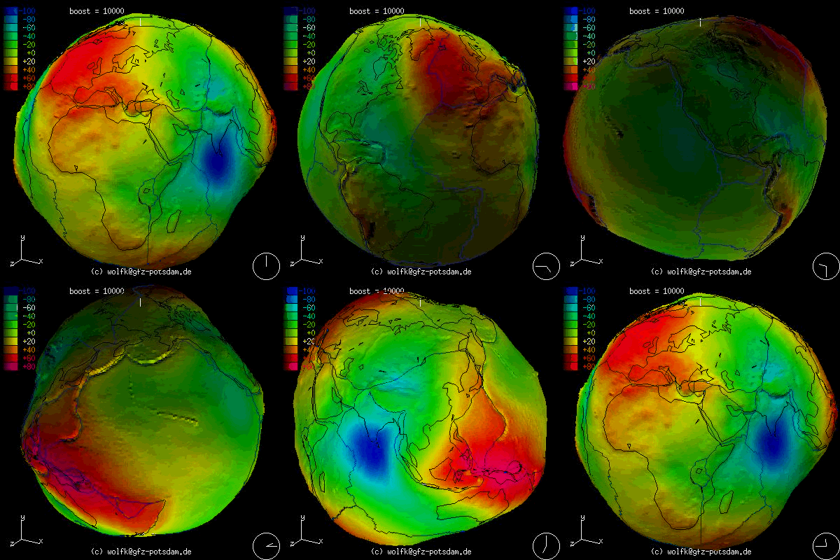
True shape of an Earth


Topography, geoids, spheroid, datum and coordinate system is a complex subject to comprehend.

Basic 

From my understanding, the earth is not flat. It is round. However, the true shape of the earth is not a perfect sphere. When we view it 2D, we can define it as ellipsoid (not a perfect one I might add). When the Earth is rotating in x, y, z axis, it can be define as spheroid. Because the shape of the spheroid is so irregular, a reference ‘shell’ is applied to the original spheroid. This ‘shell’ enclosed the system and known as geoids. Geoid is the mean sea level and the true shape of the earth. Most of the calculation is used based on the geoid. The elevation of certain of all surface topography is also relative to the geoid.

Gunung Besar Hantu


Simple trigonometry can be use if the distance between two points is small. When involving a huge distance, the so called flat plane is becoming curve. It’s hard to imagine without a proper diagram. If you take a flat piece of paper and let it ‘touch’ a single point on a sphere. On the sphere, mark point A and B. The piece of paper is aligned 900 with the normal line, N. After that you imagine a light emit in the center of the sphere. The A and B will ‘projected’ on the piece of paper. You will immediately realize that the distance between the two points is different. Its kindda rectified. The distance becoming big. Because of the properties, the mapping of a certain area of an Earth has to sacrifice in term of distance, area and terrain feature (depending on usage). This is where aerial surveillance and satellite imagery comes to play.
To understand the nature of map projection, I am trying to further my knowledge in vector calculus, trigonometry, 3D Translation, rotational and physic. I hope one day, I will contribute something in the area of topography.


Note – For Malaysia, we used Rectified Skew Orthomorphic Map projection.
The method of projection is oblique cylindrical projection. The line of constant scales skewed at an angle to the meridian.
For the map datum, we use Kertau.
What is it used for - Everything regarding to the surface of the earth. In my case, I used it for my Herping activity. I still try to analyse the mathematics involved.  

Transformation from UTM to WGS84


This post will be amend from time to time.