 |
| True shape of an Earth |
Topography, geoids,
spheroid, datum and coordinate system is a complex subject to comprehend.
 |
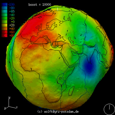
| Basic |
From my
understanding, the earth is not flat. It is round. However, the true shape of
the earth is not a perfect sphere. When we view it 2D, we can define it as ellipsoid
(not a perfect one I might add). When the Earth is rotating in x, y, z axis, it
can be define as spheroid. Because the shape of the spheroid is so irregular, a
reference ‘shell’ is applied to the original spheroid. This ‘shell’ enclosed
the system and known as geoids. Geoid is the mean sea level and the true shape
of the earth. Most of the calculation is used based on the geoid. The elevation
of certain of all surface topography is also relative to the geoid.
 |
| Gunung Besar Hantu |
Simple trigonometry
can be use if the distance between two points is small. When involving a huge
distance, the so called flat plane is becoming curve. It’s hard to imagine
without a proper diagram. If you take a flat piece of paper and let it ‘touch’ a
single point on a sphere. On the sphere, mark point A and B. The piece of paper
is aligned 900 with the normal line, N. After that you imagine a
light emit in the center of the sphere. The A and B will ‘projected’ on the piece
of paper. You will immediately realize that the distance between the two points
is different. Its kindda rectified. The distance becoming big. Because of the
properties, the mapping of a certain area of an Earth has to sacrifice in term
of distance, area and terrain feature (depending on usage). This is where aerial
surveillance and satellite imagery comes to play.
To
understand the nature of map projection, I am trying to further my knowledge in
vector calculus, trigonometry, 3D Translation, rotational and physic. I hope
one day, I will contribute something in the area of topography.

Note – For
Malaysia, we used Rectified Skew Orthomorphic Map projection.
The method
of projection is oblique cylindrical projection. The line of constant scales
skewed at an angle to the meridian.
For the map
datum, we use Kertau.
What is it used for - Everything regarding to the surface of the earth. In my case, I used it for my Herping activity. I still try to analyse the mathematics involved.
 |
| Transformation from UTM to WGS84 |
This post will be amend from time to time.
6 comments:
i definitely cannot go hiking by myself..hehehe..
Regards,
-Strider-
gunung besar hantu ?
dekat mana tu ?
waw.. style r bro.. susah bg L, tp seng bg bro.. haha
jom hayati sebentar..=)
http://lolz-l.blogspot.com/2012/01/amanahnyer-sahabat-rasulullah.html
satu usaha yang terbaik! terima kasih sudi berkongsi. anda dah sampai satu tahap yg lebih tinggi bro.. teruskan~
gunung besar hantu ? erkk ?
fuhh.. mathematik.. like3 =)
when you post something like this, whoaa..bestnya dapat buat activity outdoor yg adventure ni..
and msti kene ada knowledege kan..:D
Post a Comment